


Apartment buildings up to 16 storeys could soar above central Springvale and up to 12 storeys in Noble Park, under draft maps released by the State Government.
Eligible buildings in these “core areas” will be ‘deemed to comply’ with planning rules and be exempt from VCAT review, meaning residents will have less say.
Planning Minister Sonya Kilkenny released the proposed heights and boundaries for 23 train and tram zone activity centres across Melbourne, including near Dandenong, Yarraman, Noble Park and Springvale railway stations.
The aim is to boost housing density around transport hubs, as part of the Governmnent’s vision for 300,000-plus new homes by 2051.
“We want more Victorians to have the opportunity to live close to public transport, their loved ones, and the things that matter to them,” Kilkenny said.
In Noble Park’s CBD, height limits are lifted to at least six storeys.
This is a dramatic escalation of Greater Dandenong’s structure plan in 2023, which set maximum six-storey heights only at several specific ‘landmark’ sites.
The State Government’s proposed height limits in Noble Park include:
12-storeys: Noble Manor site (bounded by Frank, Noble and Buckley streets) and the Coles Noble Park ‘gateway’ area.
10-storeys: Noble Park RSL, as well as three landmark sites near Copas Park (off Buckley and Noble streets and Leonard Avenue)
8-storeys: Douglas Street shopfronts
6-storeys: Noble Park Public Hall and Paddy O’Donoghue Centre.
Meanwhile, Springvale CBD height limits are set to rise to a nearly uniform 12-storeys – up from a mixture of eight, 10 and 12-storey sites.
Two sites will have 16-storey limits – an area between Newcomen Road, Springvale Road and the railway line, and another bounded by Balmoral, St Johns and Buckingham avenues.
Other areas such as near Yarraman stations have been classified as ‘catchments’, with gentler height limits for low-rise apartments and townhouses.
Heritage and landscape overlays will stay in place in ‘catchments’, according to the Government.
Neighbours in these areas will still have a say to know and have a say on new developments.
Inner catchments, representing up to a five-minute walk from the station or centre, propose limits of four storeys – or six storeys on larger blocks of more than 1,000 square metres. They include neighbourhoods on the fringe of Springvale, Noble Park and Dandenong’s CBD.
Outer catchments, representing up to a ten-minute walk from the station or centre, propose limits of three storeys – or four storeys on larger blocks of more than 1,000 square metres.
Neighbourhoods near Yarraman station as well as near the rail corridor between Noble Park and Yarraman are classified as outer catchments.
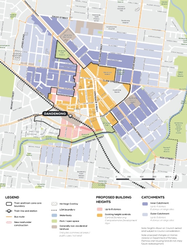
In Dandenong, most of the change is happening just outside the CBD.
Some of the new eight-storey areas include areas near the new underpass as part of Webster Street level crossing removal project, Robinson Street, Hutton and Pickett streets and the Dandenong Pavilion area between Hemmings Park and Close Avenue.
Some of Dandenong’s oldest neighbourhoods will be ‘inner catchments’ of four storeys – or six storeys on larger blocks.
They include streets around Dandenong Primary School between Foster and Power streets, including parts of Macpherson, McCrae and Pultney streets.
Other areas near Dandenong Market, Dandenong High School, Hemmings Street and Hemmings Park are also included.
Dandenong’s three-storey ‘outer catchments’ include areas around Webster Street, Jones Road and Dandenong North Primary School.
The draft maps are subject to community consultation across February and March.
To see the maps go to engage.vic.gov.au/project/activity-centres-program-stage-two/page/springvale-dandenong